Service
Site Plan Rendering: Rendered Site Plans for Marketing and Presentations
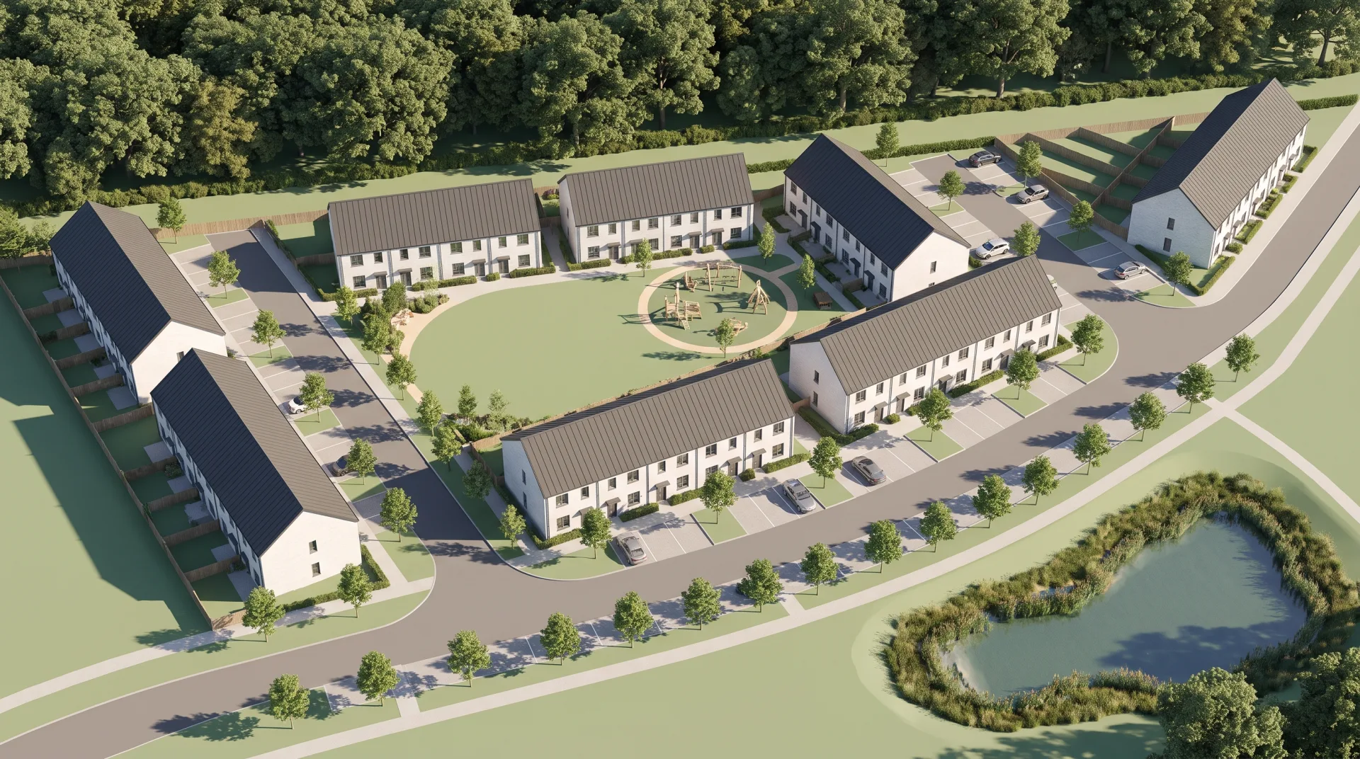
A site plan is a top-down architectural drawing of a property showing its boundaries, buildings, access, parking and landscape, and we turn your site plan drawing into a rendered color site plan for brochures, leasing websites and presentations, as part of our online 3D rendering service. A rendered site plan shows buyers, tenants and review boards where everything sits in one picture, as a 2D color plan or a 3D plan, with the first draft in 3 to 5 business days; it is a marketing drawing, not a permit or survey drawing.
Plan types
2D color or 3D
Built from
CAD or PDF site plan
2D color or 3D
Plan types
CAD or PDF site plan
Built from
3 to 5 business days
First draft
Two rounds included
Revisions
01
What is a site plan?
A site plan is a scaled drawing of a property seen from above that shows property lines, buildings, driveways, parking, utilities and landscape. It answers the questions a plan of the building alone cannot: where the building sits on the lot, how cars and people reach it, and what surrounds it. Architects, engineers and surveyors draw site plans for permits, and the same drawing, colored and labeled, becomes a sales tool.
Site plan definition
In US practice, a site plan is both a drawing many permits require and, once colored and labeled for buyers, a marketing drawing. The permit version is measured and annotated so a reviewer can check setbacks and easements. The marketing version keeps the same geometry and adds color, shadows, trees and a legend so a buyer can read it in seconds. We make the second kind, from the first.
What does a site plan look like?
A site plan looks like a map of one property: a boundary line, building footprints, paved and green areas, a north arrow and a scale. Buildings usually show as roof outlines, driveways and parking as gray or hatched areas, and trees as circles. Many of the conventions are shared with plans of buildings, so our guide to floor plan symbols also helps you read a site plan.
02
What do you get with a rendered site plan?
A rendered site plan order delivers a color top-down plan of the site with buildings, roofs, trees, planting, paving, cars and shadows, labeled for the reader you are selling to. Think of it as a site plan illustration rather than a technical sheet: the geometry comes from your drawing, and the color, texture and shade make it legible to someone who has never read a plan. A color site plan in a brochure or on a leasing website shows a buyer where their home, their parking space and the pool are in one picture. For a whole district or campus, the same work becomes a master plan rendering, with the phases or parcels picked out in color.
| Option | What it shows | Typical use |
|---|---|---|
| 2D color site plan | Flat top-down plan with color, textures, trees and cast shadows | Brochures, listing pages, leasing websites |
| 3D site plan | The site from above at an angle, with buildings shown in volume | Sales presentations and investor decks; for a full perspective of the site in its surroundings, see our aerial renderings |
| Master plan rendering | A whole development, campus or neighborhood with phases or parcels in color | Planning presentations, investor and community meetings |
| Landscape site plan | Planting, paving, water and lighting across the site | Landscape proposals and HOA approvals |
| Residential lot plan | One house, its driveway, garden and pool on its lot | Custom home builders and listing agents |
| Apartment complex site plan | Buildings, parking, amenities and paths, with buildings numbered | Leasing offices, websites and wayfinding boards |
Why teams send us their drawings
Drawn by architects
Plans, sections and finish schedules are read the way they were drawn, so the first draft is close.
Priced before we start
A fixed quote within 12 hours of receiving your files. The quote you accept is the one you pay.
A clay draft first
Camera angles and massing are agreed on a plain model before materials go on, so the final has no surprises.
Yours to use anywhere
Full commercial rights and 4K JPG and PNG files for print, web and listings.
03
Do you draw site plans for permits?
No: we render marketing and presentation site plans from drawings you already have, and permit or survey site plans must come from a licensed surveyor, engineer or architect. A rendered site plan follows the geometry of the drawing you send, but we do not check setbacks, measure boundaries or certify anything on it. If your county needs a plot plan for a building permit, have it drawn first, then send it to us to render for marketing.
04
Rendered site plan examples
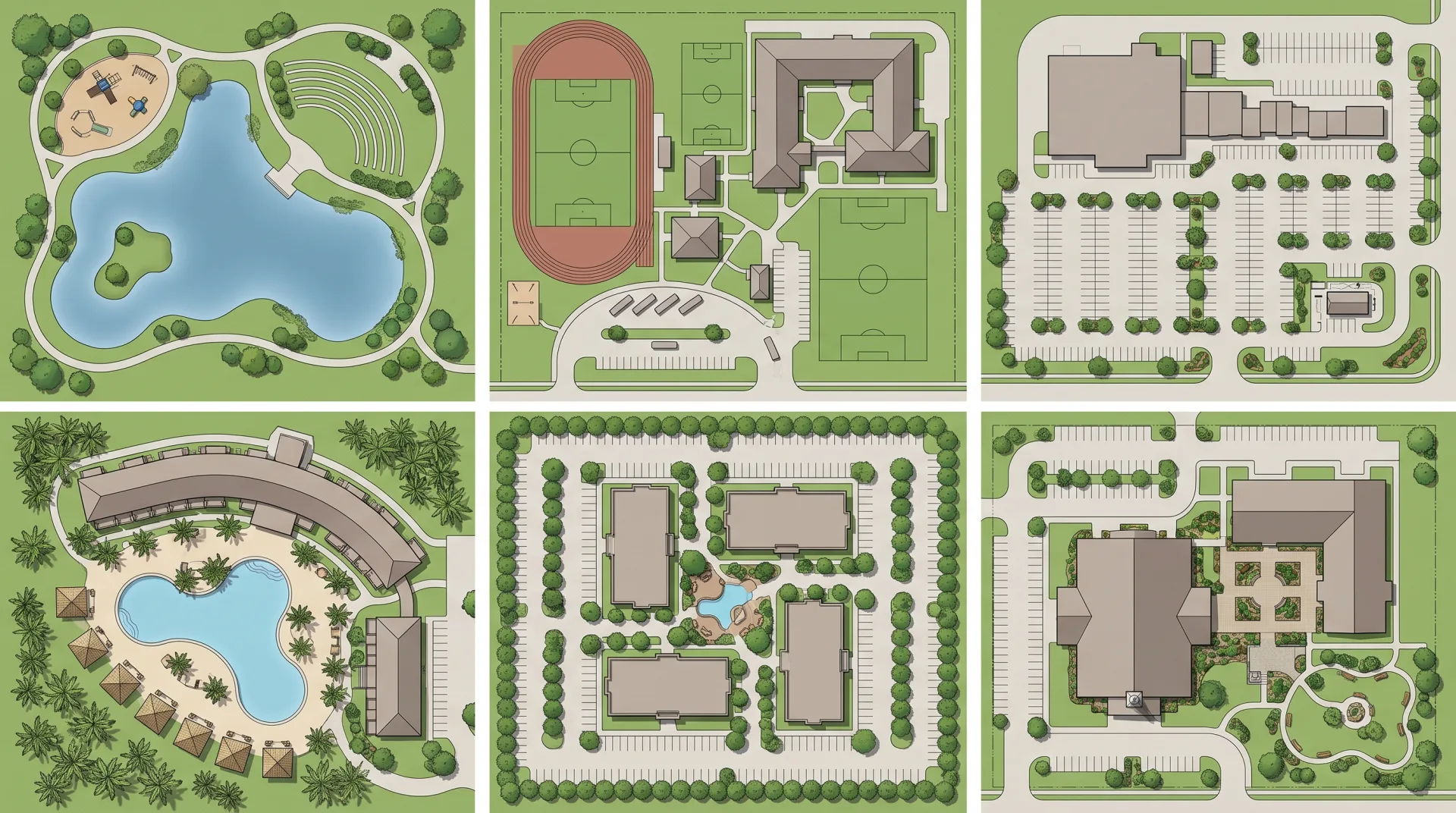
The strip below shows six rendered site plans: a public park, a school campus, a retail center, a resort hotel, a business park and a church campus, each captioned with site type and use. These site plan renderings are concept work showing the range of sites and styles we render. Each one uses the same approach: buildings as clean roof planes, a limited palette, shadows cast from one sun direction and labels kept out of the planting.
What clients said about our interior designer's work
I sent over our floor plans and a few reference photos, and they took it from there. What stood out was how little back-and-forth we needed. They understood the brief and got most things right on the first attempt. The final images were exactly what our marketing team needed.
Robert Hayes · United States
We were struggling to agree on finishes for a client's kitchen renovation. Having the different options rendered made the decision so much easier. It saved us from making what could have been a very expensive mistake. Money well spent.
Emily Carter · United Kingdom
Honestly, the first draft wasn't quite what I had pictured. I sent through my comments, and the revised version was spot on. I appreciated that they actually listened rather than rushing through the changes. Happy with how everything turned out.
Daniel Cooper · Australia
05
Site plan examples
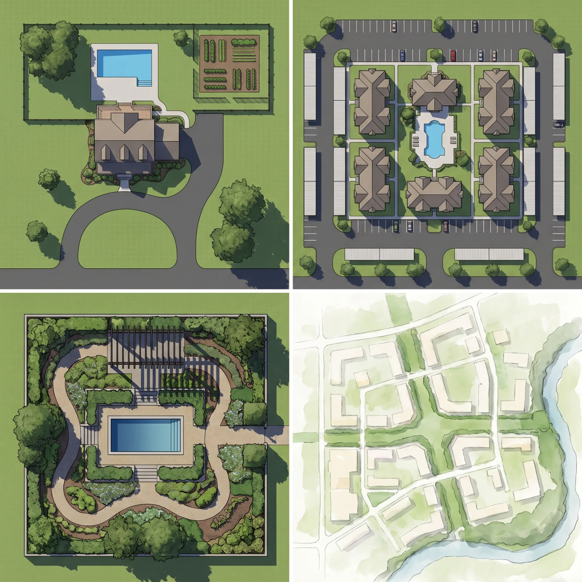
The examples below show a residential lot, an apartment complex, a landscape site plan and a conceptual site plan, each in the rendered color style we deliver.
Residential site plan
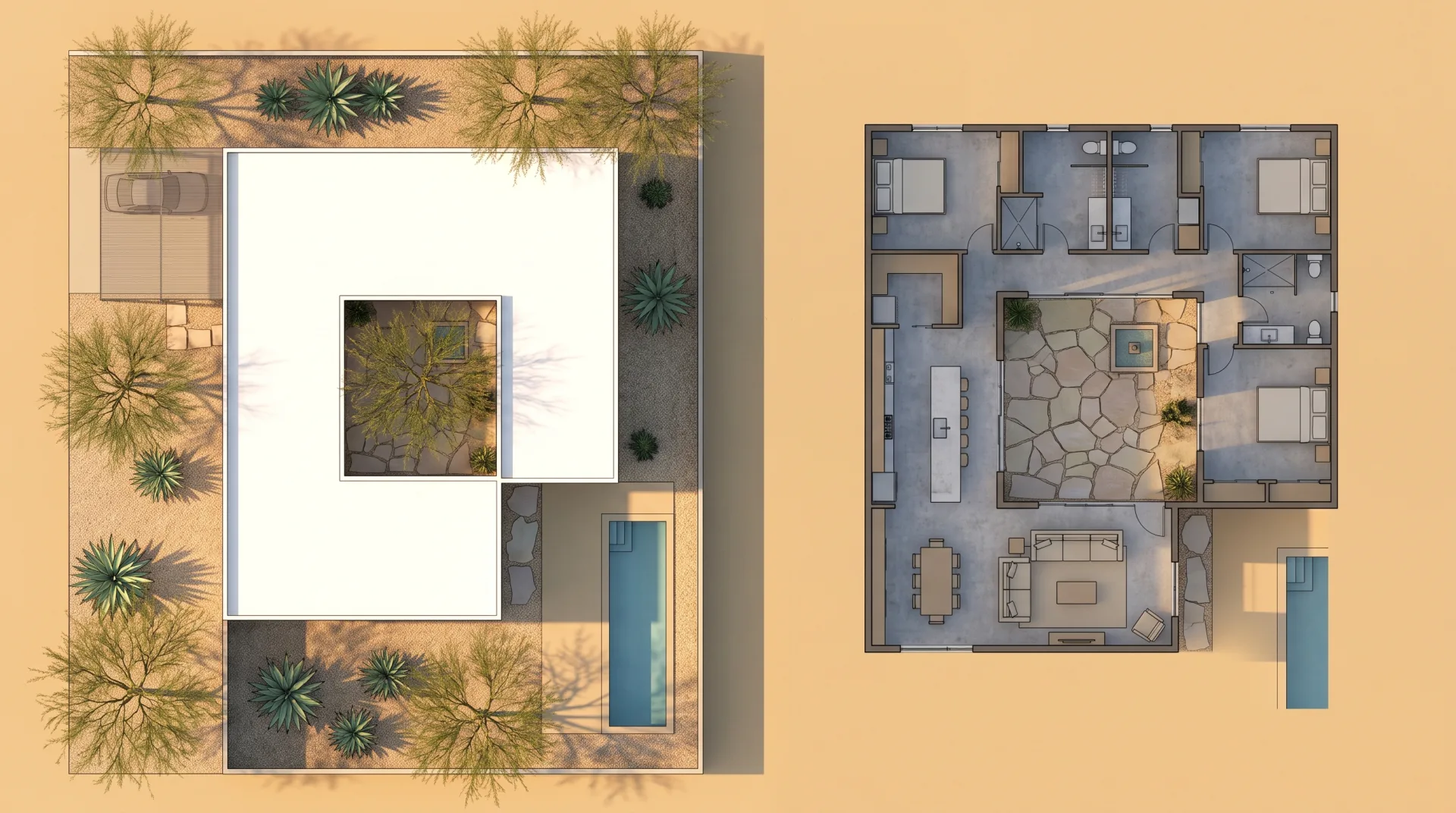
A residential site plan shows the house footprint, driveway, setbacks and garden on one lot. Rendered, it is what a custom home builder shows a buyer choosing where the pool and the patio go, and what a listing agent adds when the lot itself is a selling point.
Apartment complex site plan
An apartment complex site plan shows buildings, parking, amenities and paths so prospects can find their unit. Leasing teams pair it with apartment floor plans for each unit type, so a prospect can go from the community to the building to the unit. Our guide to multifamily marketing covers how these materials work together in a lease-up.
Landscape site plan
A landscape site plan shows planting, paving, water and lighting across the site. Planting reads best when trees are drawn by species size and canopy shape, so send the planting list with mature sizes. For eye-level views of the same garden, our landscape visualization service renders the planting as a visitor will see it.
Conceptual site plan
A conceptual site plan shows an early layout of buildings and open space before detailed design. We render these with softer edges and fewer details, so a room of stakeholders reads them as an idea rather than a decision, which is what they are.
06
What should a site plan include?
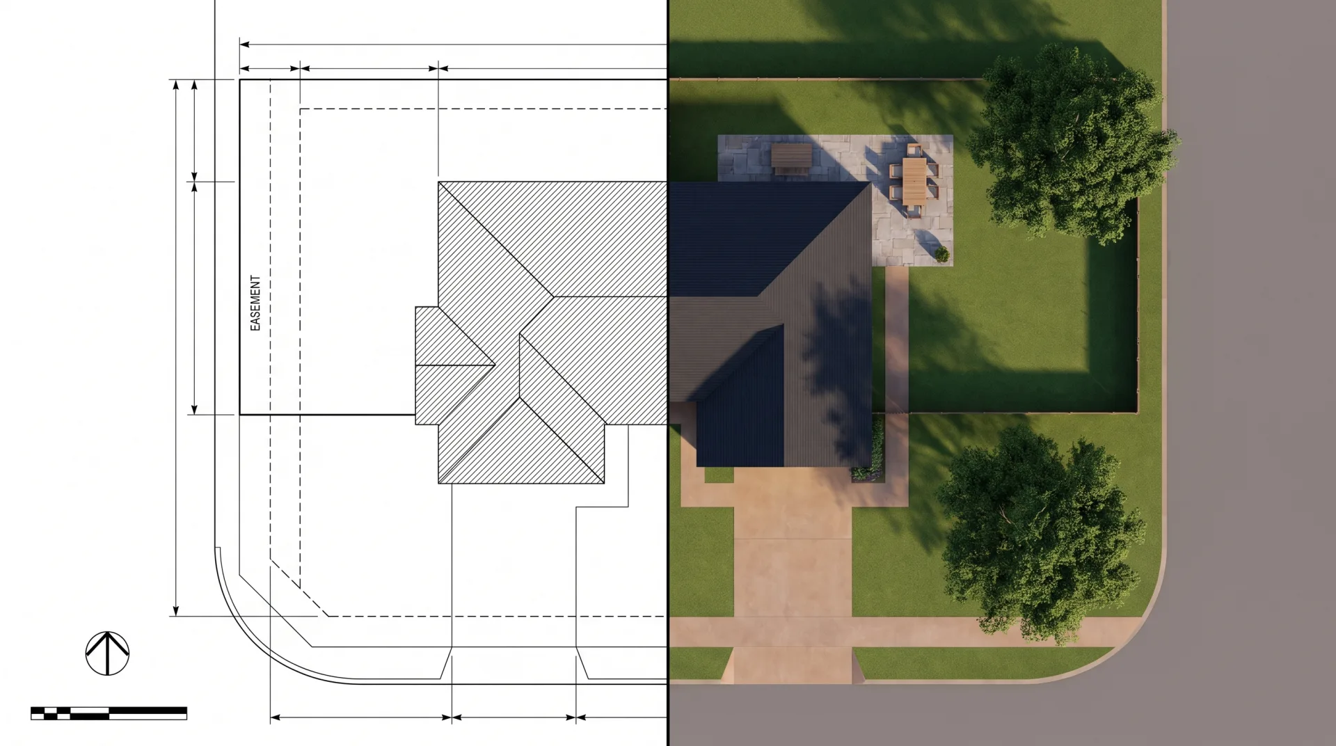
A site plan should include property lines, building footprints, setbacks, access and parking, utilities, landscape, a north arrow and a scale; a marketing site plan adds color, labels and a legend. Permit requirements vary by county: Larimer County, Colorado, for example, asks for every property line dimension, a scale of at least 1 inch to 20 feet, utility easements, parking areas and the distance from the proposed structure to each property line. The table shows how the two kinds of site plan differ.
| Element | Permit site plan | Marketing site plan |
|---|---|---|
| Property lines | Required, with dimensions | Shown as a boundary, without dimensions |
| Setbacks | Required, measured to each line | Usually left off |
| Utilities and easements | Required where present | Left off unless a buyer needs them |
| Building footprints | Required, dimensioned | Shown as roofs or footprints with shadows |
| Parking | Required, with space counts where the code asks | Shown with cars and paving texture |
| Landscape | Often a separate landscape sheet | Trees, lawn, planting and water in color |
| Labels and legend | Technical notes | Building numbers, amenities and a simple legend |
| Color and shadows | No | Yes: this is what the rendering adds |
07
Site plan vs plot plan vs floor plan
A site plan shows the whole property and what is on it, a plot plan is the term many US counties use for a simple residential site plan, and a floor plan shows the rooms inside one level of a building. Developers usually order a floor plan and site plan together, because buyers move from one to the other: where is the building, then what is inside it. Our guide to the types of floor plans explains the floor plan side of this table in detail.
| Drawing | Shows | Typical scale | Used for |
|---|---|---|---|
| Site plan | The whole property: buildings, access, parking, landscape, utilities | Varies with the site; small sites often 1 inch to 20 feet | Permits, planning review and marketing |
| Plot plan | One residential lot: boundaries, house, driveway, setbacks | Set by the county | Residential building permits |
| Floor plan | Rooms, walls, doors and windows on one level of a building | Often 1/4 inch to 1 foot | Construction, sales and listings |
What is the difference between a site plan and a plot plan?
A plot plan is usually a simpler survey-based drawing of one residential lot, and a site plan can cover any site and usually shows more design information. Counties use the terms differently, so if a permit office asks for a plot plan, follow its checklist.
What is the difference between a site plan and a floor plan?
A site plan shows the property from above, and a floor plan shows the rooms inside the building. For the rooms inside each building, we render color floor plans from the same set of drawings.
08
Who orders rendered site plans?
Developers, landscape architects, architects and leasing teams order rendered site plans for sales brochures, leasing sites, planning presentations and wayfinding boards. Developers use them across the whole sales suite, and our page on real estate development marketing shows where the site plan sits beside renderings, floor plans and animation. Architects order architectural site plan rendering for community meetings and competition boards, where a technical sheet would lose the room. Landscape architects order them to show planting at maturity, and home builders to sell lots in a new subdivision.
09
How does a rendered site plan help you sell?
A rendered site plan helps you sell because a buyer, tenant or planning board sees in one picture where the building sits, how they reach it and what surrounds it. A line drawing asks the reader to know the conventions; color, shadows and labels let someone who has never read a plan find their home, their parking space and the pool in seconds. A 3D site plan rendering models every building in volume and lights it, so it also shows height and massing, which is what investors and review panels want to judge. Our 3D rendering pricing page shows site plans beside every other service.
| Plan type | What it suits | What it does for you |
|---|---|---|
| 2D color site plan | A residential lot, an apartment complex, a landscape plan or a master plan shown flat | Gives every reader the layout at a glance, at a size that fits a brochure page or a website |
| 3D site plan | The same sites with buildings and trees in volume, seen from an angle | Shows building heights and massing, so investors and boards judge the scale |
| Aerial view | A perspective of the site in its real surroundings | Places the site among its real streets, parks and transit |
| Landscape or pool view | An eye-level view of a garden, courtyard or pool | Shows an amenity as a resident will use it |
An example. A developer launching a 120-unit apartment community puts a 2D color site plan on the leasing website, so prospects find their building and parking before they visit, a 3D site plan in the sales presentation, so investors see the massing, and three exterior views of the buildings and pool in the brochure. All five images come from the same drawing, so the plan and the views agree.
10
How long does a rendered site plan take?
A rendered site plan's first draft arrives in 3 to 5 business days from a complete CAD drawing, and the delivery date of the final is fixed in the quote.
| Stage | Time |
|---|---|
| Fixed quote | Within 12 hours of receiving your files |
| First draft | 3 to 5 business days |
| Rush delivery | 48 hours on request, subject to capacity |
11
What do you need to send us?
Send the site plan drawing in CAD or PDF, the landscape plan if you have one, and the labels and legend you want shown. A CAD file is better than a PDF because layers separate buildings, paving and planting; our page on DWG files explains the AutoCAD format most site plans are drawn in.
- 01Send the site plan as DWG or PDF.
- 02Add the landscape plan or planting list, with mature tree sizes where you have them.
- 03Include building footprints and roof plans, so roofs read correctly from above.
- 04List the legend items and labels: building numbers, unit numbers, amenities and entrances.
- 05Send brand colors if the plan sits in a brochure or on a website.
12
How do revisions work?
Revisions check layout and labels first, then color, planting and shadow style, with two rounds included. Layout errors are cheap to fix before color goes on, so the first draft is the one to compare line by line against your drawing.
- 01Check the layout on the first draft: buildings, paving, parking and boundary against your drawing.
- 02Confirm the labels and legend: names, numbers and what is shown.
- 03Comment on color, planting density and shadow direction on the colored draft.
- 04Approve the final for full-resolution delivery, with both revision rounds included in the fixed quote.
13
What file formats do you deliver?
Rendered site plans arrive in 4K as JPG and PNG, with a layered PSD on request. Tell us in the brief if the plan goes on a large printed board, and the quote states the output size. You get full commercial use, with no time or place limit.
| Format | Use |
|---|---|
| JPG | Websites, listing portals and email |
| PNG | Brochures and slide decks, and plans placed over a colored page |
| Layered PSD | On request, so your designer can move labels or change colors |
14
How do I make my own site plan?
You can draw a basic site plan from your property survey using free tools, and for permits most counties require one prepared or checked by a surveyor or engineer; we do not prepare permit drawings.
- 01Get your property survey or plat from the county.
- 02Trace the boundaries and building footprints at scale.
- 03Add driveways, setbacks and utilities.
- 04Add a north arrow and a scale.
Where do I find a site plan for my property?
Your county recorder, assessor or building department, your closing or mortgage documents, or the original builder usually hold the survey or plat for your property. A survey is the safest starting point because its boundary dimensions are measured.
Is there a free way to create a site plan?
Free drawing and mapping tools can produce a simple site plan from a survey; for a permit submission, check your county's requirements first. Some counties, Larimer County among them, do not accept aerial or satellite images in place of a drawn plan.
Questions
Can you render a site plan from a hand drawing?
Yes, if the drawing is to scale or has the key dimensions on it. Scan or photograph it flat and send it with the survey, and we trace it before rendering. A CAD file gives the most accurate result.
Can the site plan match our brochure colors?
Yes. Send your brand colors as hex, Pantone or CMYK values and we build the palette for paving, roofs and labels from them, checked on the colored draft.
Can you show future phases on the plan?
Yes. Later phases can be shown in a lighter tone or outline, so buyers see what is coming without mistaking it for what is built. Say which parcels belong to which phase in the brief.
Get a quote for a rendered site plan
Send the brief and files through the form and we reply with a fixed quote within 12 hours of receiving them. We are a 3D rendering firm of designers who know how a site goes together, working remotely for developers, architects and builders in the US and worldwide.